
"PENDOR is formed from the Latin pendeō, 'to hover', and -or, the ending that turns a verb into a noun. Its root is shared with pendō, 'to weigh'. To hover, and to weigh what lies below."
We build aircraft that hold steady above the ground and judge carefully what they see, so that care reaches every field, every structure and every place the road does not.
PENDOR designs, builds and flies autonomous drone systems: airframes shaped in simulation, open flight control, and onboard intelligence that understands where it is and what it has been asked to do.
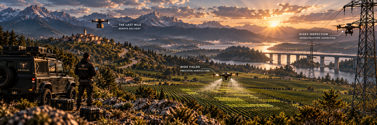
On large farms, trouble starts in one corner of a field and spreads before anyone walks past it. Spraying by hand or by tractor treats every row the same, whether it needs it or not.
Power lines, bridges, roofs and towers are still checked by people on ropes, ladders and lifts — slow, costly work that puts people at height.
Villages beyond the paved road wait longest for parts, samples and supplies, and a patrol on foot sees only what lies near the path.
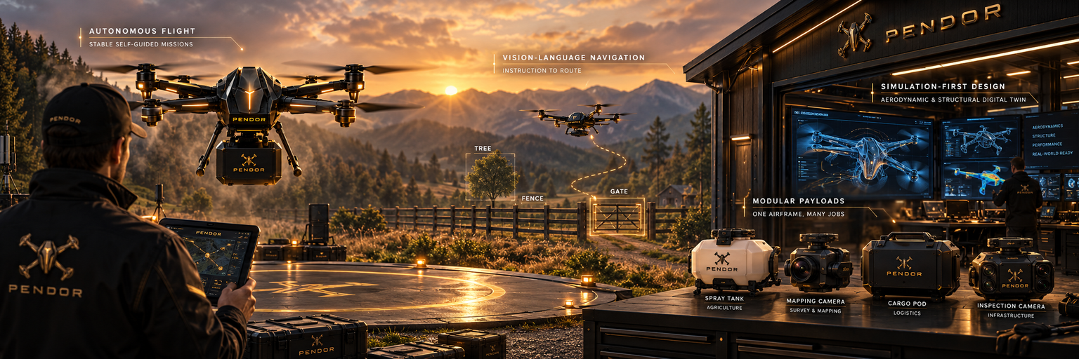
Open flight control keeps each aircraft stable in wind, holds its position and flies a full mission on its own, from take-off to landing, with an operator supervising rather than steering.
Vision-language models turn a plain instruction such as "fly along the east fence and check the gate" into a route, and read the scene below to find landmarks, obstacles and targets.
Wings, rotors and frames are shaped and tested in aerodynamic and structural simulation before any part is made, and every flight behaviour is rehearsed in a simulated world first.
A spray tank, a mapping camera, a cargo pod and an inspection camera attach to a common mount, so one fleet can take on several jobs through the season.
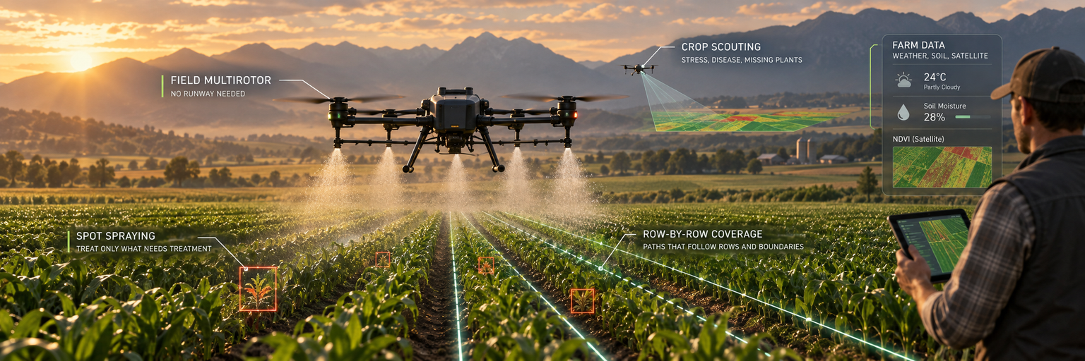
A multirotor built for farms: it takes off from the edge of a field, hovers low and steady over the crop and works row by row, with no runway needed.
Onboard weed and plant detection opens the nozzles only over the plants that need treatment, so chemicals go where they are needed and nowhere else.
Vision foundation models and plant-level segmentation read the canopy from above, marking stress, disease and missing plants on a field map.
Coverage path planning lays out passes that follow the rows and the field boundary, so no strip is missed and no strip is sprayed twice.
Aerial maps are combined with weather, soil and satellite data to show which part of a field needs water, nutrients or protection next.
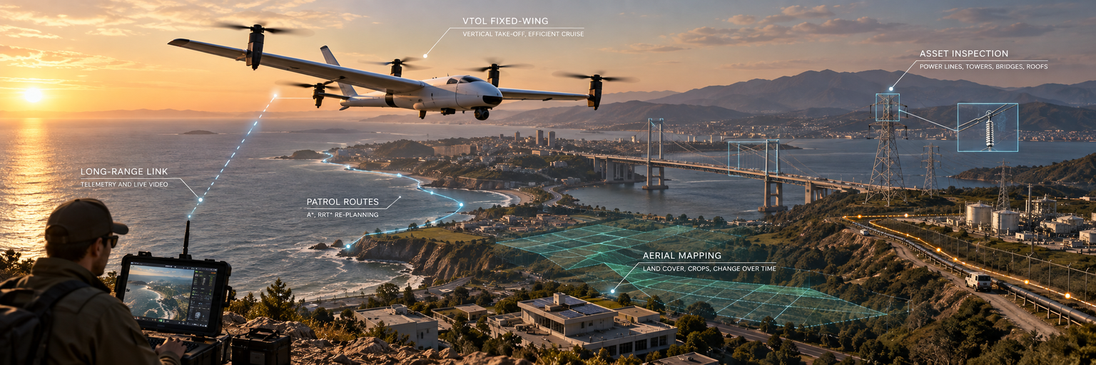
Vertical take-off and landing with a wing for cruise: it rises from a small clearing like a multirotor, then flies on its wing to cover long distances efficiently.
Imagery from each flight is read by multi-modal geospatial models alongside satellite data, turning a survey into a map of land cover, crops and change over time.
Segmentation picks out power lines, towers, roofs and bridge joints in every frame, and flags damage or vegetation growing too close.
A long-range digital link carries telemetry and live video back to the ground station, so the operator sees what the aircraft sees throughout the mission.
Graph- and sampling-based path planning (A*, RRT*) sets patrol routes over perimeters, pipelines and coastlines, and re-plans them when conditions change.
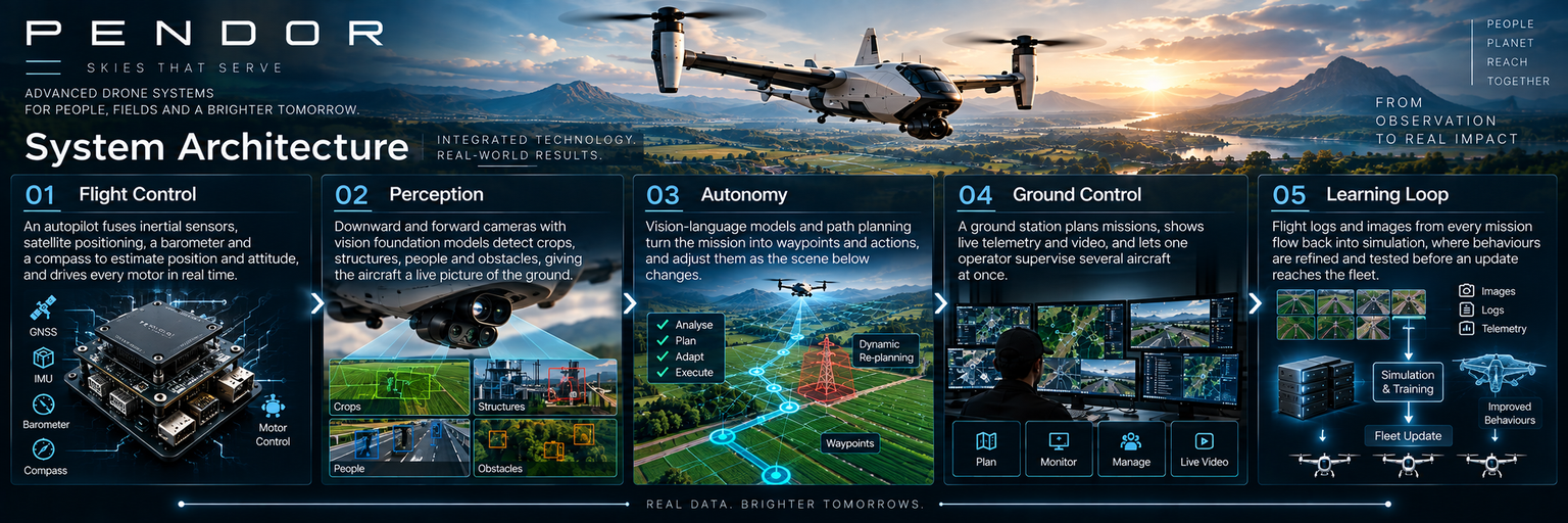
An autopilot fuses inertial sensors, satellite positioning, a barometer and a compass to estimate position and attitude, and drives every motor in real time.
Downward and forward cameras with vision foundation models detect crops, structures, people and obstacles, giving the aircraft a live picture of the ground.
Vision-language models and path planning turn the mission into waypoints and actions, and adjust them as the scene below changes.
A ground station plans missions, shows live telemetry and video, and lets one operator supervise several aircraft at once.
Flight logs and images from every mission flow back into simulation, where behaviours are refined and tested before an update reaches the fleet.
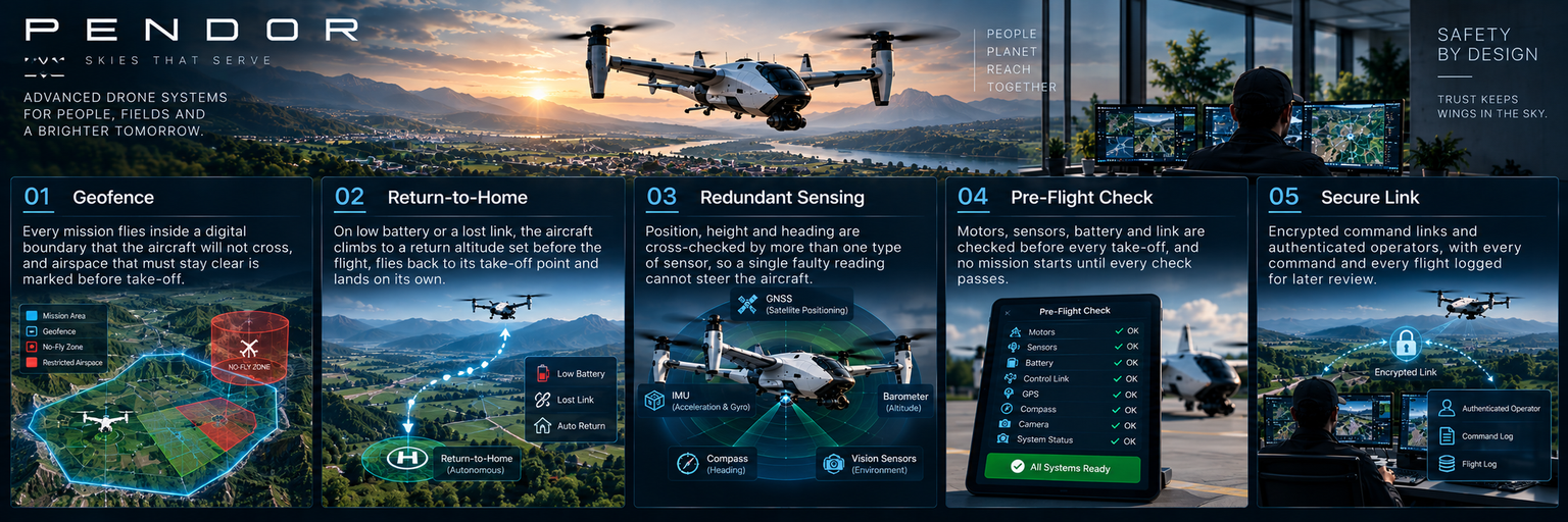
Every mission flies inside a digital boundary that the aircraft will not cross, and airspace that must stay clear is marked before take-off.
On low battery or a lost link, the aircraft climbs to a return altitude set before the flight, flies back to its take-off point and lands on its own.
Position, height and heading are cross-checked by more than one type of sensor, so a single faulty reading cannot steer the aircraft.
Motors, sensors, battery and link are checked before every take-off, and no mission starts until every check passes.
Encrypted command links and authenticated operators, with every command and every flight logged for later review.
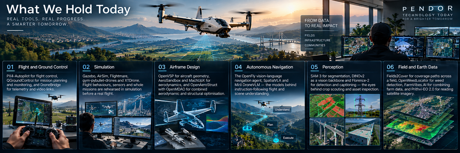
PX4-Autopilot for flight control, QGroundControl for mission planning and monitoring, and DroneBridge for telemetry and video links.
Gazebo, AirSim, Flightmare, gym-pybullet-drones and XTDrone. Flight behaviours, sensors and whole missions are rehearsed in simulation before a real flight.
OpenVSP for aircraft geometry, AeroSandbox and MachUpX for aerodynamics, and OpenAeroStruct with OpenMDAO for combined aerodynamic and structural optimisation.
The OpenFly vision-language navigation agent, SpatialVLA and Miril DroneVLM — the models behind instruction-following flight and scene understanding.
SAM 3 for segmentation, DINOv2 as a vision backbone and Florence-2 for detection and captioning — the eyes behind crop scouting and asset inspection.
Fields2Cover for coverage paths across a field, OpenWeedLocator for weed detection, FarmVibes.AI for combining farm data, and Prithvi-EO 2.0 for reading satellite imagery.
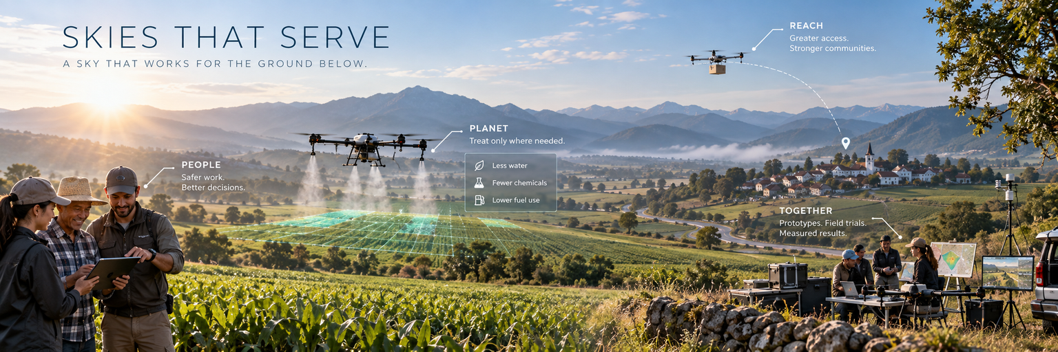
We are building toward a sky that works for the ground below it: aircraft that hover where they are needed, weigh what they see, and come back with answers people can act on.
Drones take the rope, the ladder and the sprayer's backpack, so people keep the decisions that need experience and local knowledge.
Treatment goes only where plants need it and a map replaces a guess, so fields use less water, fewer chemicals and less fuel.
A village beyond the road is mapped, supplied and watched over as well as a town beside the highway.
We will get there with the farmers, surveyors and communities who fly with us: prototypes first, then field trials, with results published here as they are measured.
"A PENDOR does not simply fly. It hovers, it weighs, and it serves the ground beneath it."
PENDOR — Autonomous Drone Systems.